Heritage & archaeology
Skerðingsstaðir has been farmed for more than five hundred years. Eight recorded remains under six register numbers lie on this parcel. They were surveyed in March 2016 for the local plan, and the development is laid out around them. This page shows where each one is, what is known of its history, how much it is worth protecting, and what the research programme will add.
Where they are
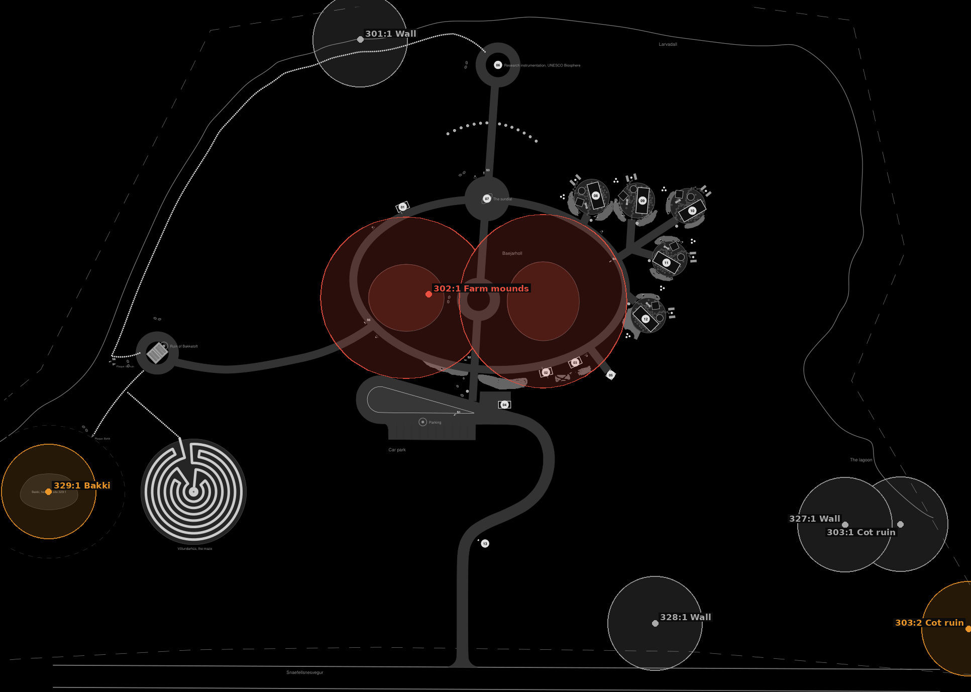
The registered sites on the master plan of The Outpost. Each point is the survey's own GPS reading, placed to within about 5 m. Shaded rings are the 15 m protected zone the law sets round every recorded remain. The two red ovals are the farm mounds and their band. Colours follow the value the survey gave: red the highest, amber considerable, grey low.
The register
302:1 · Bæjarhólar, the two farm mounds
The farmstead of Skerðingsstaðir stood here, in the middle of the home field. Mound A is about 20 by 20 m and 1.4 m high, with a ruin in its north end and a wall over its south end. Mound B is about 29 by 36 m, with a small ruin to the north, another to the east, and stones and stone rows in its south part. A low wall, probably a kitchen-garden wall, joins them. Both tops were levelled in later times, but only the youngest layers were touched. Older remains below may be very old. The farm was abandoned in 1961.
329:1 · Bakki, or Bakkahjáleiga, a croft
A ruin on a hill 7 to 18 m across. The visible house is 7 to 8 m long and 4 m wide, with turf and stone walls 1.5 to 2 m thick. Its door probably faced north-west, to the sea. A barn may lie hidden on the south-east side. The place-name register calls the ruin at the westernmost point Bakkatóft. Younger animal sheds were probably built on top of part of it. The hill may hold older remains than those seen, and Bakki may once have been larger.
303:2 · Croft ruin, perhaps Tröð
A ruin 10 by 6 m with one room and a doorway in its north gable. More ruins lie further east along the sea bank and look much older. One more, 4 by 6 m, may lie by the shore 25 m to the south-east.
303:1 · Croft ruin, perhaps Tröð
A ruin 7 by 6 m, walls of turf and stone up to 1 m high. Its west and north sides are gone, probably levelled with the field.
328:1 · A faint wall
About 100 m long, 2 m wide and only 0.1 m high, running north-east to south-west down the ness towards the sea. Well grassed and hard to see.
327:1 · Home-field wall
Turf and stone, 29 m long, 1.2 m wide and up to 0.6 m high, with a 2 m gate 10 m from its east end. It probably once ran further and may be the same wall as 301:1.
301:1 · Home-field wall
Turf and stone, 1 to 2 m wide and 0.5 to 1 m high, running west from the east tip of the ness along the sea bank. Broken in many places. It may once have closed off the whole ness.
Five centuries of Skerðingsstaðir
| When | What the record says |
|---|---|
| 1467 | Björn Þorleifsson, the King's governor and husband of Ólöf Loftsdóttir, dies. |
| 1480 | The first mention: the estate of Ólöf Loftsdóttir and her sons Þorleifur and Einar Björnsson is divided, in a deed written at Skarð on 15 April. Soon after, the farm is named again in Ólöf's division of Björn's estate. |
| 1495 | Ólöf's daughter Sólveig Björnsdóttir leaves Skerðingsstaðir, among other farms, to her sons in her will. |
| 1686 to 1697 | The oldest land register lists the farm at 12 hundreds, a large farm by the standard of the country. The figure holds from then on. |
| 1703 | The census lists three crofts, small tenant farms, on the land: Bakki, Fornakot and Tröð. At Bakki lives Guðrún Bjarnadóttir, a poor woman kept by the parish. Destitute people live in the other two. |
| about 1805 | All three crofts are abandoned, before living memory by 1847. Bakki is by then called Bakkahjáleiga. |
| 19th century | The county description says the farm reached the sea through Lárós, so it kept a boat. A boat landing has never been found. The report suggests the deep dip west of the site, or the east tip where the home-field wall ends. |
| 1961 | The farm is abandoned. |
| 2004 and 2005 | The municipal heritage register records the wall, the farm mounds and the ruins. |
| 24 March 2016 | Fornleifafræðistofan walks the whole parcel and records eight remains under six numbers. The two walls 327:1 and 328:1 and the Bakki ruin 329:1 are new to the register. |
Names on the land
Bæjarhóll
The farm mound, where the house stood.
Bakkatóft
The ruin at the west tip, named for the croft Bakki.
Kottún
The home field of the croft, a large flat in the south of the home field where the 303 ruins lie.
Bæjargil
The farm gully: the stream just west of the 303 ruins, which may have carried the farm's lane, the tröð that gave the croft Tröð its name.
Gilflöt
The flat by the gully.
Lárvaðall
The lagoon on whose shore the farm stands.
How the remains are protected
Under the Cultural Heritage Act, number 80 of 2012, every remain over 100 years old is protected. Nobody, landowner or builder, may damage, disturb or move one without the permission of Minjastofnun Íslands, the Cultural Heritage Agency. A 15 m protected zone runs from the outermost visible edge of each. Where a remain cannot be kept safe, the agency sets the response, from exact GPS recording and photography up to a full excavation. Simple ruins are usually investigated with a section cut through them, drawn, photographed and dated by the tephra layers.
The survey asks that the ground round the remains is never used as a store or a route for machines or materials without the agency's permission. It notes that if the croft ruins prove older than 1550 they should move into the highest class, and so cannot be cut into without an investigation.
From the dig to the maze
When an excavation goes ahead, it is led by an archaeologist under a permit and terms from Minjastofnun Íslands. The ground is opened layer by layer and every layer is recorded, drawn and photographed. The ash layers from known eruptions help to date each one. The soil is sieved for finds. Anything found belongs to the nation and goes to the National Museum of Iceland.
The soil itself does not leave the land. Once it has been sieved and recorded, it is carried a short way east of the Bakki hill, outside its protected zone, and built into the banks of a maze. The turf lifted from the dig is kept alive and laid back over the banks, so the same ground grows again. Nothing is wasted and nothing is trucked away. The earth that held the story of the farm becomes a place to walk and think.
Völundarhús, the maze
Völundarhús is the old Icelandic word for a labyrinth: "Völundur's house", after Wayland the smith of the old lays. Icelanders drew the classical seven-circuit labyrinth under this name for centuries. Ours is that same figure, seven rings of grass-topped earth banks about 33 m across, with one path that winds through every ring to the centre.
The stone at its heart
At the centre stands a basalt stone carved with the Vegvísir, the wayfinder stave of the Icelandic magical tradition, recorded in the 19th-century Huld manuscript "so that one will never lose one's way in storms or bad weather". Around its foot, Viking-age runes of the Younger Futhark spell VÖLUNDARHÚS.
How much earth it keeps
Banks 0.7 m high hold about 295 m³ of dug soil, and about 880 m² of turf goes back over them. If the dig yields less, the banks are built lower and the plan stays the same: 0.6 m banks take about 254 m³, 0.9 m banks about 380 m³.
Where it is
East of the Bakki hill, its outer bank 20 m from the hill and 5 m outside the hill's 15 m protected zone. The entrance faces the ruin, joined to it by a line of stepping stones.

The maze is a design for comment. It is built only after the excavation, and only if the agency agrees to the terms.
What the research programme adds
Fixed-point cameras watch the eroding sea bank at the shoreline ruins, so the landscape record doubles as a heritage-risk record. Frames appear under Cameras. Any geophysics and any licensed excavation will be reported here as results come in, on the partners' schedule.
Source: Bjarni F. Einarsson, Fornleifaskráning vegna deiliskipulags á Skerðingsstöðum í Eyrarsveit, Snæfellsnessýslu, Fornleifafræðistofan, March 2016, prepared for Jogh ehf. Values are the survey's own, on its scale of 10. The 1467 and 1480 dates follow the survey's sources in Íslenskt fornbréfasafn.